

Hurricane Harvey
Flooding Imminent for areas Previously Flooded
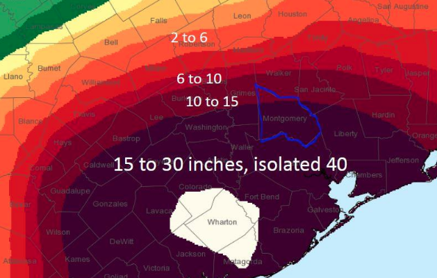
Montgomery County – August 28, 2017 – Montgomery County Office of Emergency Management
We are still expected to receive an additional rainfall amount between 10 and 15 inches throughout the rest of the week. In the last 24 hours, the county has seen between 4 and 6 inches of rain.
The grounds are saturated, rivers and creeks continue to swell. Areas that flooded in 1994 will be inundated with water again. If you are in a low lying area prone to flooding, you need to get to higher ground now. We have several Red Cross Shelters open and receiving evacuees. If you receive a message on your mobile device to evacuate, do so immediately.
We currently have 5 shelters open in Montgomery County.
Bull Salas Park – At Capacity
21679 McCleskey Road
New Caney, TX 77357
College Park High – Still has room
3701 College Park Drive
The Woodlands TX
Lone Star Convention Center – At
capacity
9055 Airport Rd.
Conroe TX 77303
St. Simon and Jude – At Capacity
26777 Glen Loch Road
Spring, TX 77381
Underover Fellowship – At capacity
600 South Frazier Street
Conroe TX 77301
If you would like information on how to help, please call 936-523-3900.
Watches and warnings remain in effect for Montgomery County:
– Flash Flood Watch until August 30, 07:00pm
– Flash Flood Warning until September 2, 5:30am
We are out of high water barricades. Do not take it for granted that if there isn’t a barricade that the road is safe to drive over. Motorists should use extreme caution when driving as some flooded or damaged roads may not be barricaded until we can
secure more barricades. Flowing water on roadways can easily sweep a vehicle off the road. If you can stay at home, please do, do not drive unless you absolutely must. Please do not go out sightseeing. Turn around Don’t Drown.
The latest road closures can be found on mctxoem.org and on drivetexas.org.
Current river forecast:
– The West Fork of the San Jacinto near Conroe is currently in major flood stage at 126.9 ft. and is forecast to crest Tuesday afternoon in major flood stage at 127.4 ft.
– The East Fork of the San Jacinto near New Caney is currently in major flood stage at 79.96 ft. and is forecast to crest Tuesday morning in major flood stage at 80 ft.
– Spring Creek near Spring is currently in major flood stage at 111.45 ft. and is forecast to crest Tuesday morning in major flood stage at 111.5 ft.
– Spring Creek at Tomball is currently cresting at 166.35 ft.
– Peach Creek near Splendora is currently cresting at 22.12 ft.
– Caney Creek near Splendora is currently cresting at 24.11 ft.
– The West Fork of the San Jacinto near Porter is currently in major flood stage at 92.35 ft. and is forecast to crest Tuesday afternoon in major flood stage at 98.1ft.
For help and information on preparing for disasters, download our new preparedness app ReadyMCTX to your mobile device. Now is the time to make sure preparations are in order and check your emergency kits.
To receive emergency alerts to your phone or email from Montgomery County Office of Homeland Security and Emergency Management, register at https://www.smart911.com/. When you are creating
your profile, you must check the box next to Share my Smart911 Profile with TXMontgomery-County-911 to support emergency preparedness.
Stay informed and monitor conditions for Montgomery County and the ssurrounding area on the Office of Homeland Security and Emergency Management website www.mctxoem.org.


0 comments